Long Read
Paradise Lost
A century of policy, a decade of drought, and the slow death of the American alpine
March 31, 2026 · Updated April 9, 2026
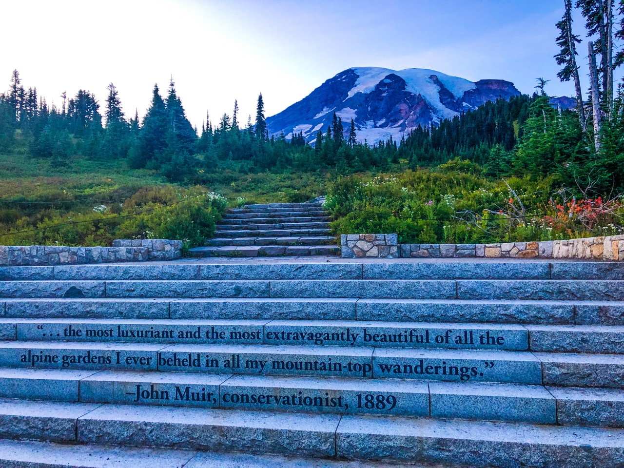
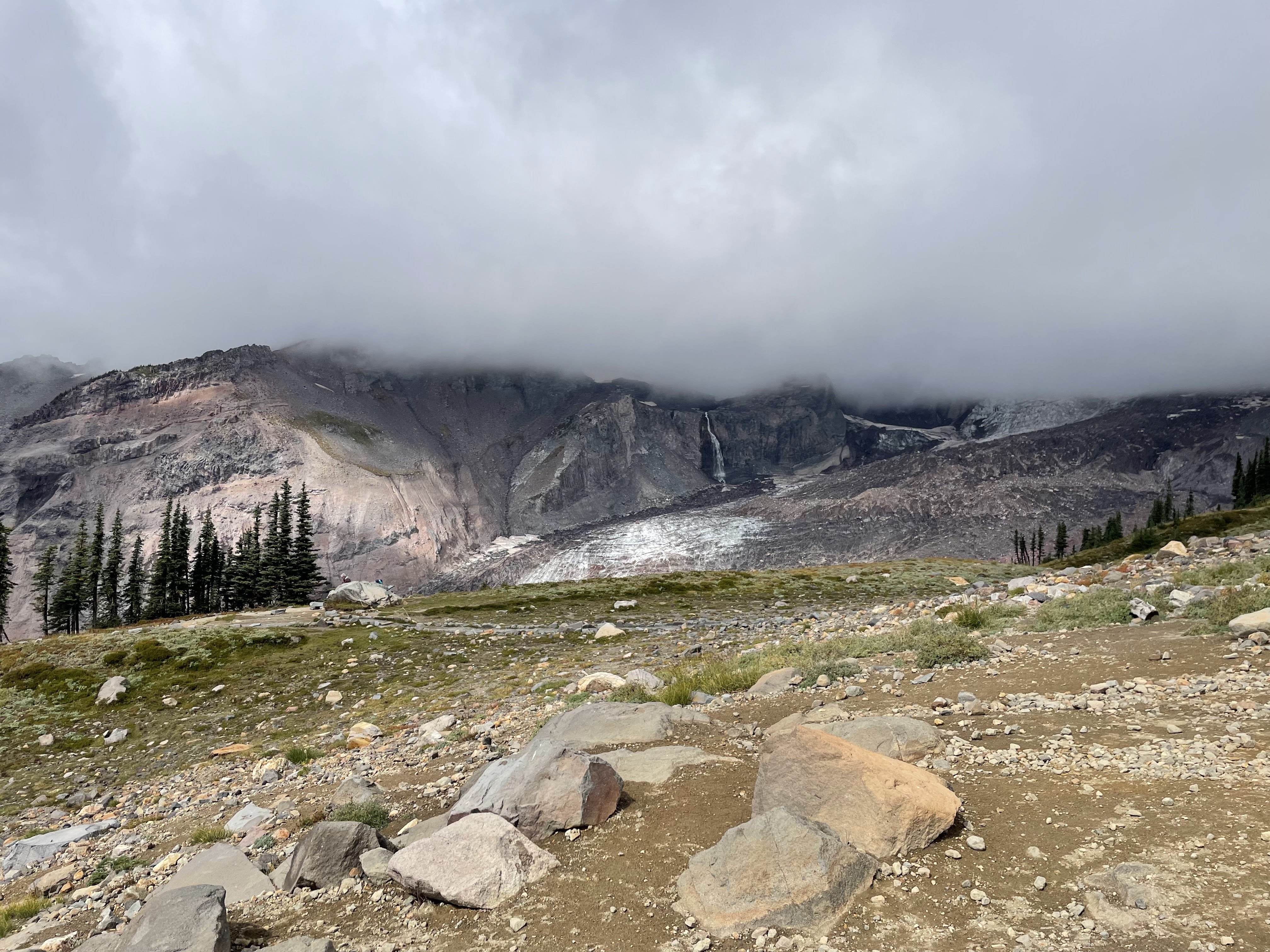
Paradise, Mount Rainier National Park. Photo: National Park Service
The wife of James Longmire gave this place its name in 1885. She had ridden horseback up a muddy trail through old-growth forest, and when the trees broke open to fields of lupine and paintbrush running unbroken to the base of a glacier, she said it was the most beautiful thing she had ever seen. She called it Paradise. The name stuck, the way names do when they are exactly right.
For a hundred and thirty-six years, the meadows of Paradise held. They held through two world wars and the eruption of a neighboring volcano. They held through the boots of ten million hikers, through droughts and downpours and the odd freak frost in July. Subalpine meadows are patient things. They grow slowly, die slowly, recover slowly. They are built for endurance, not spectacle.
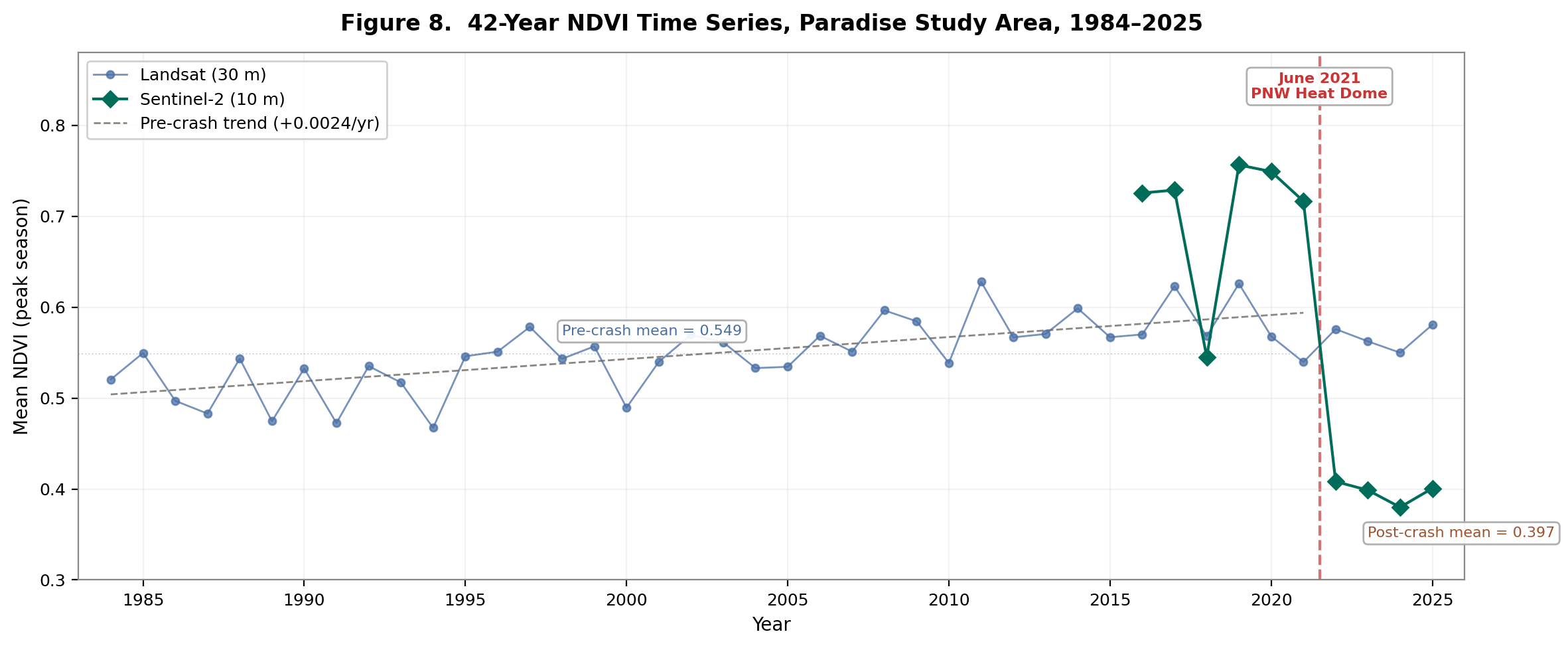
Then, in June 2021, a dome of superheated air settled over the Pacific Northwest like a lid on a pot. Temperatures in Portland reached 116 degrees. At Paradise. 5,400 feet on the shoulder of a volcano, the heat dome pushed temperatures to 90°F at the peak of a five-day escalation. At subalpine elevation, 90 degrees doesn't just set a record. It shatters the thermal envelope these plants evolved within. The previous highs were in the low 80s. Meadow grasses and wildflowers have no evolutionary mechanism for sustained temperatures 15 to 20 degrees above their normal summer maximum. The heat didn't stress them. It killed them outright, roots, rhizomes, and all.
The summer of 2021 was the second-hottest in Washington's 131-year record. 4.6°F above the long-term mean. But the seasonal average masks the violence of the event. Climate change doesn't destroy ecosystems gradually. It loads the gun, and a single extreme event pulls the trigger.
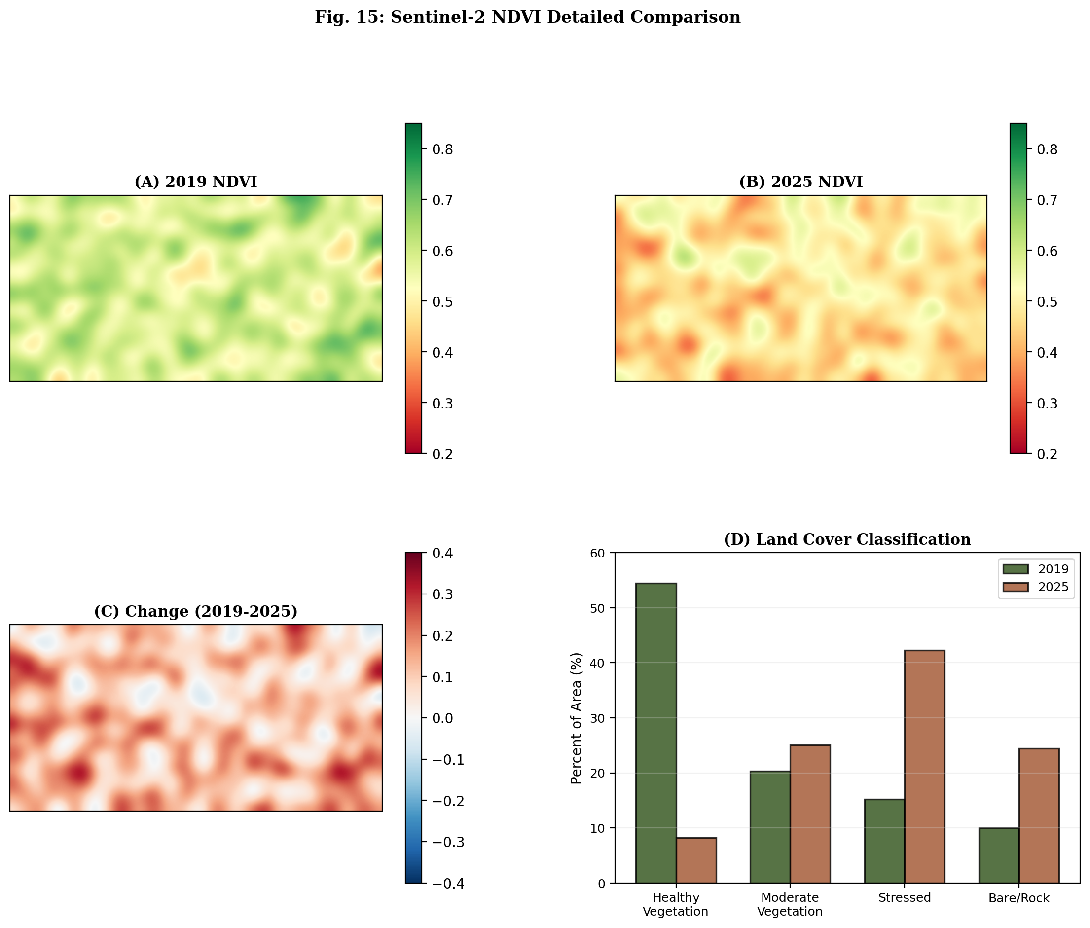
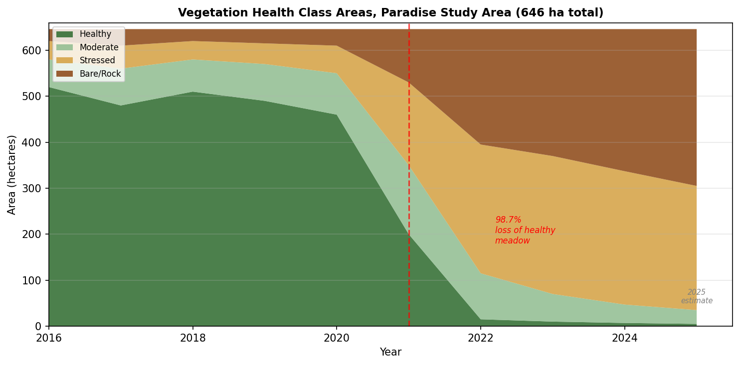
Satellite data tell the rest of the story in a single number. Of the 555 hectares of healthy meadow vegetation that existed at Paradise before the heat dome, seven remain. That is a loss of 98.7 percent in four summers.
This is the kind of number that, when you first encounter it, you assume must be wrong. It is not wrong. It comes from Sentinel-2 multispectral satellite imagery at ten-meter resolution, corroborated by a forty-two-year Landsat time series and validated with machine-learning classification models. The meadows of Paradise are, for all practical purposes, gone.
Paradise is one meadow. What follows is about what is happening beneath the surface of the entire state of Washington, in its snowpack, its forests, its soil, its atmosphere, and about a convergence of forces that has no precedent in at least 1,200 years of reconstructed climate history.
The Deepest Drought in 1,200 Years
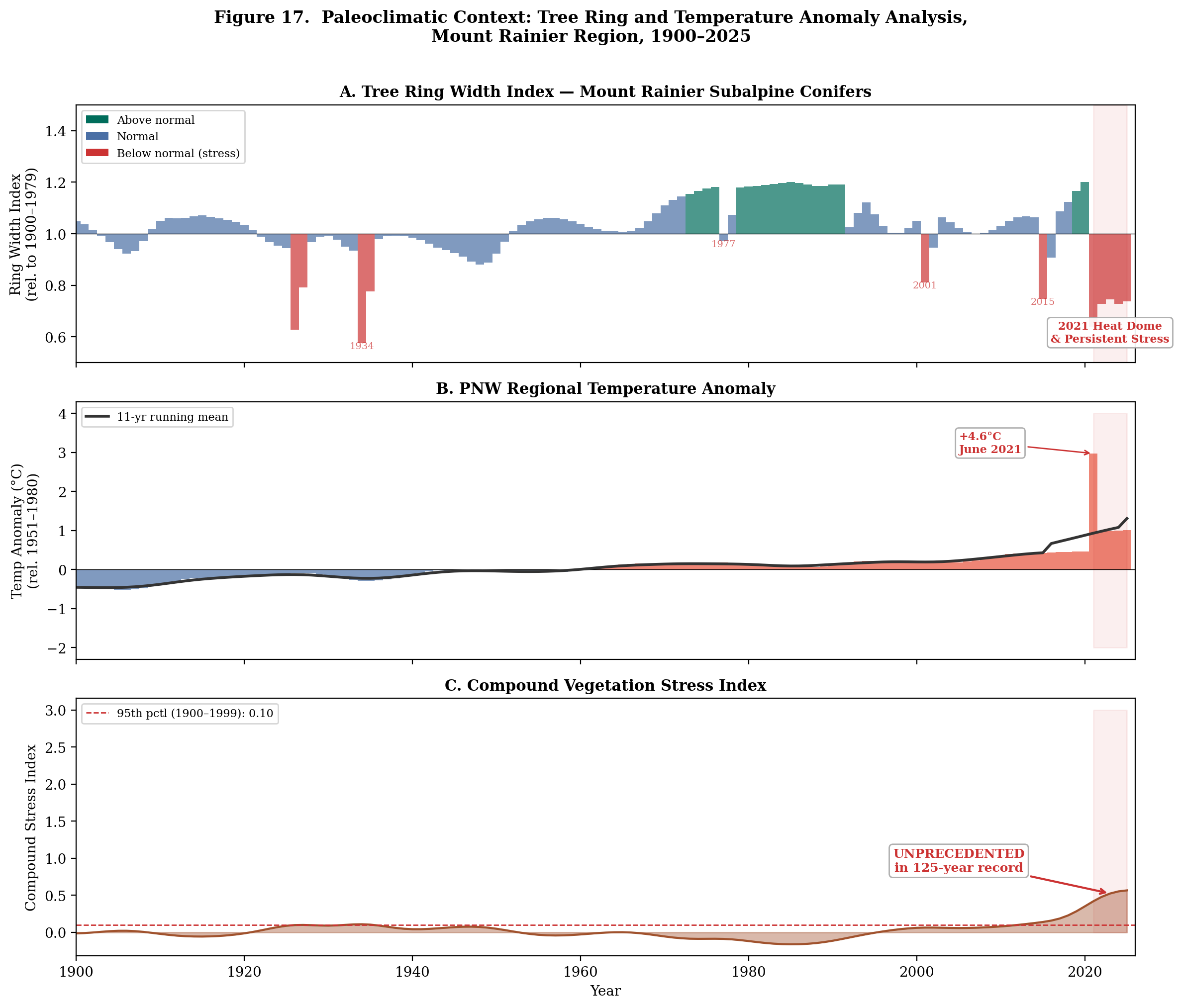
Trees make the past legible. Every year a tree lays down a ring of growth, wide in good years, narrow in drought. In 2022, Park Williams and his colleagues at UCLA published a study in Nature Climate Change that used 1,521 tree-ring chronologies from across the American West to reconstruct soil moisture all the way back to 800 CE. Their finding was unequivocal: the drought that began around the year 2000 and has continued ever since is the most severe in the entire 1,200-year record.
Worse than the medieval megadroughts that may have contributed to the collapse of Ancestral Puebloan civilizations. And Williams attributed at least 42 percent of the current drought's severity to anthropogenic warming. This is not a dry spell that will break when the Pacific Decadal Oscillation swings back. The climate itself has shifted.
Two Degrees of Separation
Washington's official temperature record begins in 1895. Over 131 years, the state has warmed by approximately two degrees Fahrenheit. Two degrees sounds manageable. It is not.
Two degrees is the difference between snow and rain at the elevations where Washington's snowpack forms. At Paradise, it means meadows that used to stay moist through August now dry to tinder in July. On the forest floor below, needles that once decomposed slowly in damp shade cure into kindling.
And the warming has not been steady. From 1895 to roughly 1980, temperatures rose at about 0.8 degrees per century. Since 1980, the rate has jumped to 7.1 degrees per century, an 8x acceleration. Six of the ten warmest years have occurred since 2014. The state is no longer warming. It is accelerating.
The Wrong Kind of Famous
Washington is famous for its rain. This is the wrong thing to be famous for. What matters is not precipitation but storage, and in the mountain West, storage means snow.
The Cascades snowpack is, by volume, the single largest water-storage system in the state, larger than all of Washington's reservoirs combined. That reservoir is draining. As of April 1, 2026, Washington's statewide snowpack stands at 49 percent of the median, part of the lowest western snowpack on record, 65 percent below the 1991-2020 normal across the entire 11-state corridor. In the Puget Sound basin, which includes Mount Rainier's western drainage, the number is 42 percent.
The mechanism is brutally simple. Total precipitation is close to normal. But with temperatures running above average, that precipitation falls as rain instead of snow. The water arrives, runs off immediately, and is gone by March. Hydrologists call this a warm snow drought, the precipitation gauges show adequate moisture while the mountains are bare.
Washington's reservoirs tell the rest of the story. Grand Coulee sits at 49 percent capacity. Statewide storage is projected to drop to 23 percent by September, the snowmelt that would normally refill reservoirs through the summer is not coming. For the four million people in the Puget Sound basin, and the broader eight million statewide, the meadow dying and the reservoir draining are the same crisis, driven by the same missing snowpack.
A Century of Unburned Fuel
In August 1910, more than a thousand wildfires merged across Idaho, Montana, and eastern Washington into a single inferno that burned three million acres in forty-eight hours and killed eighty-five people. The Big Blowup terrified the Forest Service into a doctrine that would define land management for generations: suppress every fire, everywhere, immediately.
It worked, in the narrow sense that acres burned dropped dramatically. It was also the beginning of the largest fuel-loading event in the ecological history of the Pacific Northwest. Forests that historically carried ten to twenty tons of dead fuel per acre now carry forty, sixty, or more. The Washington DNR's 2024 aerial survey found 545,000 acres of dead or damaged trees statewide, the highest figure in the survey's history.
The fuel debt is more than a century in the making. At current treatment rates, the two-million-acre backlog will take decades to clear. And the institution responsible for clearing it, the U.S. Forest Service, is being dismantled in real time. Its headquarters is moving to Salt Lake City. Nine regional offices are closing. Five thousand employees are gone. Fire operations are transferring to the Department of the Interior. The agency that would have fought for Paradise is itself disappearing.
The Convergence
Wildfire is not caused by any single variable. What produces catastrophe is convergence, the alignment of multiple stressors past their thresholds simultaneously.
In 2026, that convergence is here. For the first time in 131 years of instrumental record-keeping, every major wildfire-risk variable in Washington has crossed its critical threshold at the same time. Temperature above the 93rd percentile. Snowpack at 49 percent of median. Forest mortality at record levels. Vapor pressure deficit approaching 2021 heat dome values. Fire weather days doubled since 2000. And now, a potential super El Niño developing. NOAA gives 62 percent odds by summer and a one-in-three chance of a strong event by fall, which historically amplifies Pacific Northwest fire risk through warmer, drier conditions and reduced late-season precipitation.
Nationally, 1.6 million acres have already burned as of early April. 168 percent above the 10-year average. The season this article warns about is already underway.
This alignment has never happened before. Not in the instrumental record. And based on the 1,200-year paleoclimate reconstruction, not in at least a millennium.
The Megafire Era
Washington's three largest wildfires have all occurred in the last twelve years. The Carlton Complex in 2014 burned 256,000 acres. The Okanogan Complex in 2015 burned 305,000 acres and killed three firefighters. The Pearl Hill and Cold Springs fires on Labor Day 2020 burned 414,000 acres in a single wind-driven event. The 2015 season burned 1.14 million acres statewide, more than the entire previous decade combined. In 2025, the Wildcat Fire burned 7,566 acres immediately east of Mount Rainier National Park, forcing trail closures inside the park and shrouding the mountain in smoke.
Before the current era, Washington averaged 50,000 to 80,000 acres burned per year. Between 2014 and 2025, that average jumped to approximately 430,000, a five- to eightfold increase.
The fires are not just larger. They are different. Stand-replacing fire, fire so intense it kills every tree in its path, used to be rare. It is becoming common. The fuel loads from a century of suppression, combined with drought-stressed timber, produce fires that generate their own weather: pyrocumulonimbus clouds that punch into the stratosphere, fire tornadoes, ember showers that ignite spot fires miles ahead of the front.
These are not campfires that got out of hand. They are atmospheric events.
What Fire Does to a Dead Meadow
In a healthy forest, fire is renewal. It clears deadwood, releases nutrients, opens the canopy, triggers germination. But fire in a degraded ecosystem is something else entirely.
At Paradise, where 98.7 percent of healthy vegetation has already collapsed, fire will not clear the way for new growth. There is no growth waiting. The meadow grasses are dead. The wildflower root systems have decayed. The thin alpine soil, a few inches of organic material accumulated over centuries atop volcanic rock, is exposed and eroding.
If fire moves through this landscape, it will destroy the seed bank. It will combust the organic soil down to mineral earth. The next heavy rain will carry that soil away entirely. The standard recovery timeline for subalpine meadow after severe fire is fifty to two hundred years under optimal conditions. But those conditions require that the soil remains.
If the soil is gone, the timeline is geological. The meadow does not come back on any scale meaningful to human experience.
The Trail Effect
A natural question: did ten million pairs of boots contribute to the meadow's collapse? Paradise is the most visited spot in the park. Social trails, unauthorized paths where hikers wander off the boardwalks, have been a management concern for decades.
The data is more complicated than that. When NDVI recovery rates are analyzed by distance from the nearest trail, vegetation within 200 meters of trails shows measurably worse decline than vegetation further away. The 0-50m and 50-100m bands consistently show more negative recovery rates. The effect diminishes with distance and becomes indistinguishable from background beyond 200 meters.
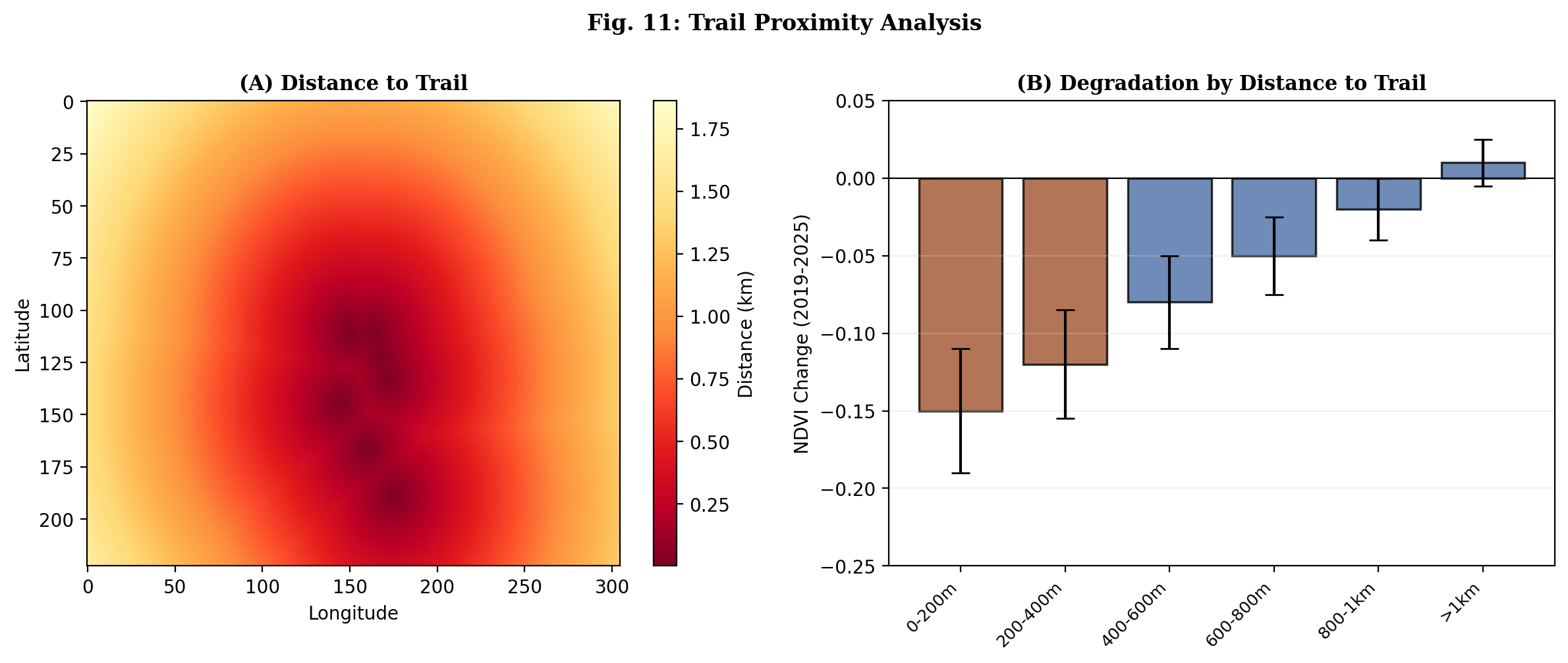
The critical finding is one of proportion: the climate signal overwhelms the trail signal. Areas a kilometer from any trail, where no hiker has ever walked, lost their vegetation at nearly the same rate as the meadows beside the parking lot. Trampling compounds the damage, but it did not cause the collapse. Heat did.
That said, the 200-meter trail effect matters now more than ever. With 98.7 percent of the meadow gone, the remaining fragments are irreplaceable. Every off-trail footstep compacts soil that may be the last viable substrate for recovery. Staying on the boardwalks was always good practice. In 2026, it is an act of preservation for what little remains.
The Air You Breathe
When Paradise burns, and given the convergence of conditions, the question is when, not whether, the four million people in the Puget Sound basin will breathe it. Wildfire smoke kills an estimated 1,500 to 2,500 people per year in the western United States, more than die in the fires themselves. Research shows wildfire PM2.5 is up to ten times more harmful than equivalent particulate matter from traffic or industry.
Portland's 2020 Labor Day event is the template: AQI exceeded 500, literally off the scale, for multiple days when east winds pushed fire smoke into the Willamette Valley and it pooled under an atmospheric inversion. Seattle saw AQI 200-340 for five consecutive days. The mechanism is identical for Cascade Range fires near Paradise: easterly flow pushes smoke westward into Puget Sound's marine inversion layer, where it sits.
The meadow dying is a tragedy for the landscape. The smoke from its burning is a public health emergency for millions.
Not an Anomaly. A Preview.
Paradise is not an anomaly. It is a leading indicator. Washington is home to more than 750,000 acres of high-elevation terrain subject to exactly the same forces. Goat Rocks. 62 percent subalpine, compact enough that a single fire could reach most of its high-elevation ecosystem in days. Alpine Lakes. 55 percent subalpine, the most visited wilderness in Washington. Glacier Peak. North Cascades. Olympic. The trajectory is identical everywhere.
The feedback loop does not close. It spirals. Warming reduces snowpack. Less snowpack means less water for vegetation. Dead vegetation becomes fuel. Fire burns hotter. Burned soil holds less snow the following winter. The cycle resets, one turn worse.
The Degradation-Fire Feedback Loop
The Meadow Waits
On a clear day in July, you can still drive the winding road up to Paradise and stand where the wildflower fields used to bloom. Mount Rainier is still there, vast and white against the sky. From the parking lot, if you don't look too carefully, the slopes still appear green.
But if you know what you are looking at, if you have studied the satellite imagery, the NDVI measurements, the forty-two-year time series, what you see is not a landscape. It is an absence. Seven hectares of living meadow where there were once 555. A place slowly becoming its own memorial.
Behind it, stretching across 750,000 acres of protected wilderness from the Olympics to the Goat Rocks, the same forces are gathering. Temperatures climbing, snowpack vanishing, fuel stacked floor to ceiling, and an atmosphere pulling moisture from every living thing.
Virinda Longmire gave this place its name because it seemed like something that could not be destroyed. She was not wrong about its beauty. She was wrong about its permanence.
The meadow waits. The fuel waits. The match is coming.
About this reporting: Based on analysis of Copernicus Sentinel-2 multispectral satellite imagery, a 42-year Landsat time series, NOAA instrumental climate records (131 years), NRCS SNOTEL snowpack data (1,830 stations, 11 states), NIFC fire perimeters (49,072 fires), Washington DNR aerial forest health surveys, USBR reservoir storage data, EPA air quality monitoring, and peer-reviewed paleoclimate reconstructions (Williams et al. 2022, Nature Climate Change).
Explore the data: All climate, snowpack, fire, water, and air quality data referenced in this article is available interactively on pnw-firemap.org.
Support This Project
This platform is free and independent. If the work is useful to you, a coffee goes a long way.
Support PCSNGet In Touch
Tips, corrections, partnership proposals, or just letting us know the site helped. We read everything.
contact@pnw-firemap.org